


1. Context
This consultation is published by Plan Bleu, Regional Activity Center of the Mediterranean Action Plan (MAP), established in the form of a French association in Marseille, France. The MAP is one of the main components of the Regional Seas Programme of the United Nations Environment Programme (UNEP). It has a legal instrument: the Barcelona Convention and relies on six regional activity centres (“RACs”) responsible in particular for promoting the implementation of the various protocols attached to the convention. Plan Bleu is one of the six centres mandated by the twenty-one countries Parties to the Barcelona Convention and the European Union (Contracting Parties to the Barcelona Convention). Plan Bleu acts as an observatory of the environment and sustainable development in the Mediterranean, and conducts thematic, systemic and prospective analyses to enlighten decision-makers of the region on the environmental risks and the challenges of sustainable development.
The Mediterranean region, with its rich biodiversity and diverse ecosystems, is increasingly threatened by human activities and climate change. Seagrasses are one of the most productive and valuable ecosystems on Earth (Murphy et al., 2021; Valdez et al., 2020; van Katwijk et al., 2016). Numerous studies have recognized its ecological and economic value, which would disappear along with them, as they provide important ecosystem services such as, nutrient cycling, sequestration of carbon, a habitat for thousands of fish and invertebrate species and a source of food for many of them, among others (Bidak et al., 2021; Terrados et al., 2013). Posidonia oceanica (L.) Delile is an endemic seagrass of the Mediterranean Sea which forms vast meadows (>2 million hectares) between the surface and 40 metres depth. This engineer species is the keystone of a major ecosystem, which offers several ecosystem services, due to its high primary production (a planetary scale), its biodiversity and its ability to store and sequester carbon for millennia. The main causes of the regression of the Posidonia meadows are associated with water quality, construction of coastal infrastructures, laying of underwater pipelines and cables, anchoring, aquaculture facilities and trawling. The species is relatively resistant to temperature variations and competition with alien species, whereas it is reported as to suffer from even slight fluctuations of salinity and turbidity, as well as the increase of sedimentation rate. In addition, Posidonia oceanica has a slow growth rate (on average between 100 and 1 000 cm per century) that makes recovery difficult when impacted. In fact, because of its intrinsic features and ecological needs, Posidonia meadows are exposed to multiple threats due to the strong and global anthropic pressure that characterises the Mediterranean as a whole. As the degradation of the Posidonia meadows concerns many Mediterranean countries, a regional approach is required to better protect the Posidonia meadows (Pergent-Martini C. et al., 2024).
ARTEMIS is an Interreg Euro-MED thematic project running from 2024 to 2026 which aims at accelerating the restoration of seagrass meadows in the Mediterranean through innovative Payment for Ecosystem Services (PES) schemes and an ecosystem-based approach. Some of the ecosystem services that the project will focus on are habitat creation (biodiversity), carbon sequestration and storage (blue carbon), and recreation, including activities such as snorkelling and diving. The objective of the present call takes place in the framework of Activity 1.5 and aims to deliver an Online map showcasing other relevant restoration actions in the Euro Mediterranean area and beyond.
The objective of this activity is to design and deliver interactive online maps that highlights past and ongoing seagrass restoration initiatives, across the Euro-MED region and the South Mediterranean, with a focus on Posidonia oceanica meadows, but also other seagrass species, by June 2026.
The map(s) will be used to :
- Showcase past and current restoration projects (ARTEMIS pilot sites, other projects/networks)
- Facilitate the engagement of external parties interested in supporting restoration efforts (e.g. businesses, donors etc.)
A preliminary work of building a database of Mediterranean seagrass conservation projects has been achieved.
2. Objectives and activity description
The consultant/expert will be responsible for:
- Reviewing and re-structuring the existing database of seagrass conservation and restoration projects. This first step will be crucial for the remaining activities described below. From the listed project, rigorous data harvesting, standardization and mapping will be realized.
- Categorizing projects by various filters/tags such as project status (ongoing/completed), seagrass species (posidonia, cymodocea etc), type of restoration activities (passive/active), funding source, including layers or visual cues to indicate restoration sites
- Identifying ARTEMIS pilot sites, including project results on ecosystem services valuation, restoration techniques, payment for ecosystem services developed, policy recommendations etc.
- Participating in coordination meetings with ARTEMIS partners and incorporating feedback during development.
- Delivering a final version of the maps (fixed maps and interactive ones in MapX), along with related metadata, user documentation and a short technical note.
- Developing online, user-friendly and visually appealing interactive maps hosted on Plan Bleu MapX Observatory as well as on ISPRA national platform that was developed in the framework of the LIFE SEPOSSO project. To do so, GIS analytic tools will be mobilized and spatialized dataset (under adapted format such as shp. and/or gpkg.) will be shared with Plan Bleu Observatory. The mirroring of the map will be supported by Plan Bleu Observatory experts.
Candidates are welcome to suggest several maps and other key features in their technical offer.
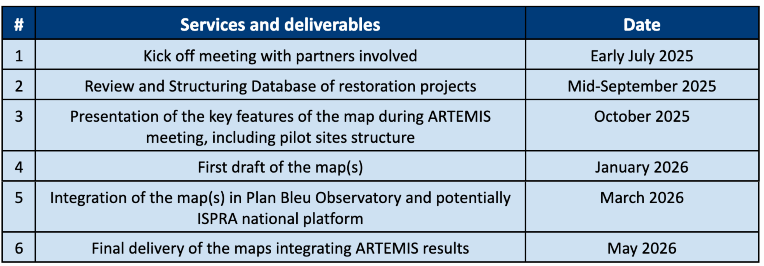
3. Timeline of services and deliverables
Timeline of services is presented in the table below :
4. Work assessment
The Consultant will be supervised by Plan Bleu’s ARTEMIS team and one representative of Plan Bleu Observatory:
- Arnaud Terrisse, Biodiversity Programme Officer, [email protected]
- Alice Wittevrongel, Biodiversity Project Officer, [email protected]
- Samson Bellières, Green and Blue transition Project Officer and GIS expert, [email protected]
Coordination and regular communication with ARTEMIS partners will be expected
5. Budget
The available budget for this consultancy is 10 000 euros VAT included and proposals should not exceed this amount.
6. Selection criteria
This mission is open to consultant consortia and individual consultants. Candidates qualified for this mission must meet the following criteria:
Experience :
- Proven experience in geospatial data visualization and interactive web mapping (e.g. GIS platforms, open-source tools like Leaflet, Mapbox,ARCGIS, QGIS, etc.).
Key Skills and Knowledge :
- Strong knowledge of marine ecology and Posidonia meadows challenges with regard to Mediterranean context; knowledge of other seagrass species (Cyomodocea nodosa, Zostera marina) appreciated.
- Strong data flow and GIS (with QGIS and/or ArcGIS) skills
- Ability to work collaboratively with project teams in international and multicultural environments
- Ability to translate scientific or conservation data into accessible, policy-, user-friendly and user-relevant tools.
- Fluency in English;
7. Consultant selection
The selection of the expert will be based on the evaluation of their technical offer (proposed methodology of action and detailed skills in relation to the qualifications required as described above and the proposed approach of the call) and an evaluation of the most economically advantageous offer.
8. Contractual, Financial, and Practical Conditions
The acceptance of the selected offer implies acceptance of the terms and detailed schedules outlined in these Terms of Reference, including the following payment schedule (negotiable) :
- 30% of the contract amount will be paid upon signature of the contract
- 70% of the contract amount will be paid upon validation of the final map
A properly issued invoice will be required for the scheduled payments, containing the following mandatory details:
- Full name + address of the service provider
- SIRET number (France) or tax number (for non-France)
- Invoice issuance date
- Invoice number
- Service description (e.g., name of the deliverable)
- Amount excluding taxes (HT), VAT, and total amount (TTC), in the currency specified in the contract
- For individuals not subject to VAT (France): include the mention “TVA non applicable, article 293B du code général des impôts”
- Payment due date
The payment term for invoices will be as follows: bank transfer within 15 days after the invoice date.
The tax legislation in force at the time of acceptance of the offer will apply.
9. Application procedures
Interested candidates are invited to submit the following documents :
- A technical offer, including a resume showcasing relevant experience
- A financial offer
The application files must be submitted no later than 27th of June via www.planbleu.org and by email to the attention of [email protected] and [email protected].
For more information, please contact: Alice Wittevrongel, [email protected] and Arnaud Terrisse, [email protected]