- Plan Bleu
Plan Bleu's missions
Make the Mediterranean a cooperation area for sustainable development
- themes
- projects
- Ressources
- publications
- Events
In the news
Last events
- Plan Bleu
Plan Bleu's missions
Make the Mediterranean a cooperation area for sustainable development

Providing socioeconomics insights for the appropriate management of Mediterranean resources

Facilitate a science – political and civil society interface

Supporting the transition towards a green and blue economy

Design possible futures for sustainable development

Observer of the environment and development to inform governments and the general public
- themes
- projects
- Ressources
- publications
- Events
In the news
Last events

Home » Imagine Method
Imagine Method
“Imagine” – A set of tools and methods to support territorial approaches and Integrated Coastal Zone Management in the Mediterranean.
Territorial approaches & “Imagine” method
Plan Bleu does not only work at regional and national scales: this UNEP/MAP Regional Activity Centre develops also “territorial approaches” and systemic analysis at local scale in different kinds of area such as ICZM sites, urban agglomerations, watersheds, tourist destinations, forest areas, marine protected areas, etc.
With environmental concerns coming increasingly to the fore in a context of more decentralized decisions, social and political demands are being made in favour of public involvement in the design and implementation of long term territorial strategies. In this context Plan Bleu has developed, tested and consolidated, in close collaboration with Dr Simon Bell (Open University, UK), the “Imagine” method for Systemic Analysis and Prospective of Sustainability, involving local stakeholders and using participatory approaches in the framework of several UNEP/MAP Coastal Area Management Programmes(CAMPs): Malta (2000-2002), Lebanon (2002-2003), Algiers (2003-2005), Slovenia (2005-2006), and Cyprus (2006). The Plan Bleu’s role consisted mainly of supporting the implementation of “Imagine” by the local teams of those CAMPs.
“Imagine”provides tools to describe, assess and examine the level of sustainability of an eco-socio-system in the past, present and future by means of indicators and based on a participatory approach considering local stakeholders as experts within their own area. This method has proven its strengths in producing shared insight into a given coastal area (diagnosis, scenarios, action plans…) and fostering stakeholder participation, thus leading to the identification of more desirable futures and the drafting of action plans collegially defined and approved.“Imagine” is a suitable tool for providing support to ‘territorial projects’ and the preservation of environmental resources.
Systemic analysis, prospective studies, and participatory approaches at the local scale
The Plan Bleu’s systemic and prospective approaches at the local scale consist of studying the past, present and future impact of development on the environment and natural resources. Those approaches aims at supporting ‘territorial managers’ and local decision-makers in using systemic and prospective analysis tools which allow to shape possible futures and, subsequently, to define action plans to move towards more desirable and sustainable futures. Intended to address and anticipate the territory in the light of past and present actions and trends, foresight analysis and scenario building methods are suitable tools to support decision-making: imagining possible (sustainable or unsustainable) futures leads to the identification of the route towards more desirable ones.
To explore the interaction between development and the environment, the Plan Bleu’s prospective approach draws on (i) system analysis and (ii) the scenario method:
- On the one hand, by taking into account the interaction between various components and key-drivers, the systemic approach allows a territory and its future to be analysed as a whole, as well as to take into account the interactions between the various elements comprising the system.
- On the other hand, the scenario method allows the possible futures of a given area to be sketched out. The scenarios and its descriptive narration (storylines) comprise a baseline picture, a choice of development hypotheses (assumptions), the path towards the chosen timeframe, and an image of the final situation, all bound together by a coherent internal logic based on the combination of trend hypotheses and their consequences: e.g. the“What if…” and“If…, then...” reasoning. Designing scenarios provides to decision-makers and local stakeholders a range of possible alternatives of the future, enabling to better grasp the issues at stake and the risks relating to the trends observed, as well as to establish measurable medium and long term progress objectives.
Revisiting “Imagine“: participation and stakeholder dialogue
“Imagine” is a participation-based tool to support decision-making, engaging the expertise of stakeholders to define management projects and actions towards more sustainable spatial planning. The “Imagine” local participatory workshops provide unique opportunities to discuss and debate common issues. The “Imagine” method proved its ability to decompartmentalise the work of local stakeholders in a given area, to make them work together towards defining a sustainable common future, and to provide information about complex situations. “Imagine” represents also a mediation tool: stakeholder participation, facilitation of discussion and exchange of opinions, search for a common language and compromise, and multi-disciplinary thinking are complementary components of what can be called”participative prospective“.
Given his role of interface between scientists and decision-makers, Plan Bleu is currently involved in several regional collaborative projects, particularly in research projects funded by the EU (Seventh Framework Programme – FP7). Plan Bleu is currently involved in two FP7 projects focusing especially on marine and coastal ecosystems:

“Imagine” is based on four key-principles:
- The systemic approach makes possible to address a given area as a whole.
- The scenario method aims at defining trend and alternative pictures of the future.
- The indicators and their thresholds of sustainability are intended to monitor trends with regard to sustainable development.
- The participatory methods rely on the expertise of local stakeholders in designing and controlling management and development projects.
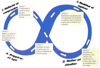
“Imagine” is based on four stages:
- Reflect and understand. Reflecting upon and understanding the system, the context of the area, and the key issues at local scale.
- Connect and investigate. Associating and analysing the interacting components of the system, identifying key indicators of sustainability, clarifying their definition and assessing their sustainability value. That means linking diagnosis of the system to the indicators of sustainability, establishing their band/belt of equilibrium and portraying them.
- Model and explore. Modelling and exploring the future of the territorial system, using the scenario method as well as the representation of the indicators sustainability and of their future development in graph form (diagrams, radars).
- Do and suggest.Suggesting and acting by establishing an action plan for sustainable local development, including the monitoring of the territorial system’s progress towards sustainable development.
Publications
events
News

-
Plan Bleu
Tour la Marseillaise
2 bis, Boulevard Euroméditerranée
Quai d'Arenc
13002 Marseille - France - [email protected]
- +33 (0)6 43 08 20 23
