


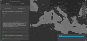
Plan Bleu, through its missions of scientific expertise and of Observatory on environment and sustainable development, provides decision-makers, managers, scientists and the general public with data, indicators and analyses to contribute to a better understanding of environmental issues. In order to provide optimal support to the decision-making process of public authorities, various tools have been developed to illustrate the major trends in the relationship between environment, human development and among others climate change, such as MapX, the cartographic application of the World Environment Situation Room (WESR) managed by the UNEP.
Developed by UNEP/GRID in Geneva, MapX is a digital infrastructure for interactive sharing of geospatial data illustrating the evolution of the state of the environment over time according to several criteria. The data are available through “views”.
Plan Bleu regularly publishes thematic views. This work is coordinated internally at Plan Bleu by Mr Antoine Lafitte, Head of the Observatory. Four new views have been published in October 2022, enhancing the category entitled “Coastal and Marine Risks”. These views show respectively the UNESCO World Heritage sites under erosion and flood risks by 2100 , according to two main scenarios defined by the UNFCCC, 2.6 and 8.5. This information comes from a recent work published in National Geographic. These scenarios regroup major patterns, representative of the work of experts on the evolution of the state of the environment due to human activities.
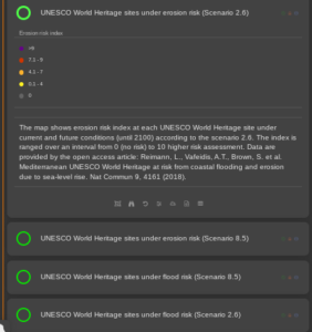
The main conclusions of this study show that scenario 2.6 is the least alarmist (low global warming), while scenario 8.5 presents a worst situation (high global warming) regarding the impacts induced by more intense and frequent extreme climatic phenomena.
Four combinations can thus be found in MapX:
- UNESCO World Heritage sites under erosion risk (scenario 2.6)
- UNESCO World Heritage sites under erosion risk (scenario 8.5)
- UNESCO World Heritage sites under flood risk (scenario 2.6)
- UNESCO World Heritage sites under flood risk (scenario 8.5)
The MapX application has been designed to offer users numerous functionalities for interacting with data (available through maps, graphs, time sliders, etc.) in a simple and accessible format.